Charles Wright & the White Horse of Inkpen

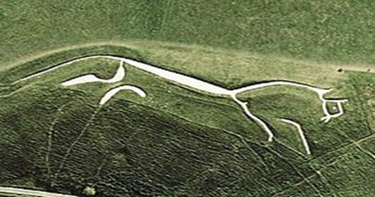
There are many hill figures cut into the chalk downland of southern Britain. The oldest and probably the most famous is the Uffington White Horse in Oxfordshire (formerly in Berkshire before 1974) cut into the scarp slope of the North Wessex Downs overlooking the Upper Thames Valley, which is over 3,000 years old.

The Uffington white horse

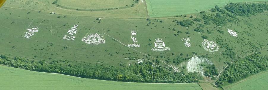
By contrast, the Fovant Badges were originally cut in the years after the First World War. These depictions of  military badges were cut to honour the hundreds of soldiers who had been training near the village of Fovant in south west Wiltshire.

Fovant badges Marchibald.fly via Creative Commons

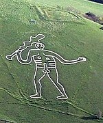
Dorset boasts two hill figures. The horse and rider on Osmington Down near Weymouth was created in 1808 in honour of George III, a frequent visitor to the town. However, no one really knows why the Cerne Abbas giant  – a figure of more likely humorous or satirical intent – was created above the village in Early Medieval times.

Humerous or satirical intent?
Pete Harlow via Creative Commons

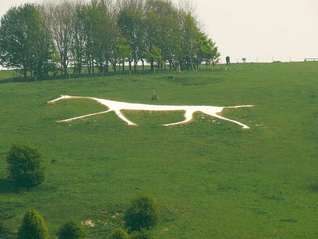
However, the majority of white horses can be found across Wiltshire. The Westbury white horse is believed to have been made sometime in the late seventeenth century which would make it the oldest figure in the county. Next comes the white horse above Cherhill, which is believed to date from 1780. Pewsey’s  horse was cut in 1785 and then in 1808, pupils at a boys’ school in Marlborough constructed the town’s white horse.

The Cherhill white horse
Brian Robert Marshall via Creative Commons

At Broad Hinton, it is believed that the parish clerk, Henry Eatwell, may have been responsible for the Hackpen Hill white horse, which was constructed in 1838 to commemorate Queen Victoria’s coronation. 

Broad Hinton white horse
Brian Robert Marshall via Creative Commons

The Devizes white horse first appeared in 1845. Then, rather later than the rest, Broad Town in 1885.  

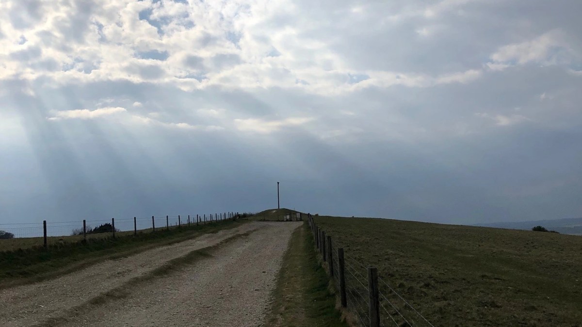
But how many people know that, sometime in the early 1870s, Inkpen was added to this list?

The Ordnance Survey map, Berkshire, Sheet XLI, surveyed in 1873 and published in 1877, does  indeed show another white horse, situated on the north facing slope of Inkpen Hill and just over the county boundary in Wiltshire.

So, who was responsible for Inkpen’s white horse and what happened that we can no longer see it?

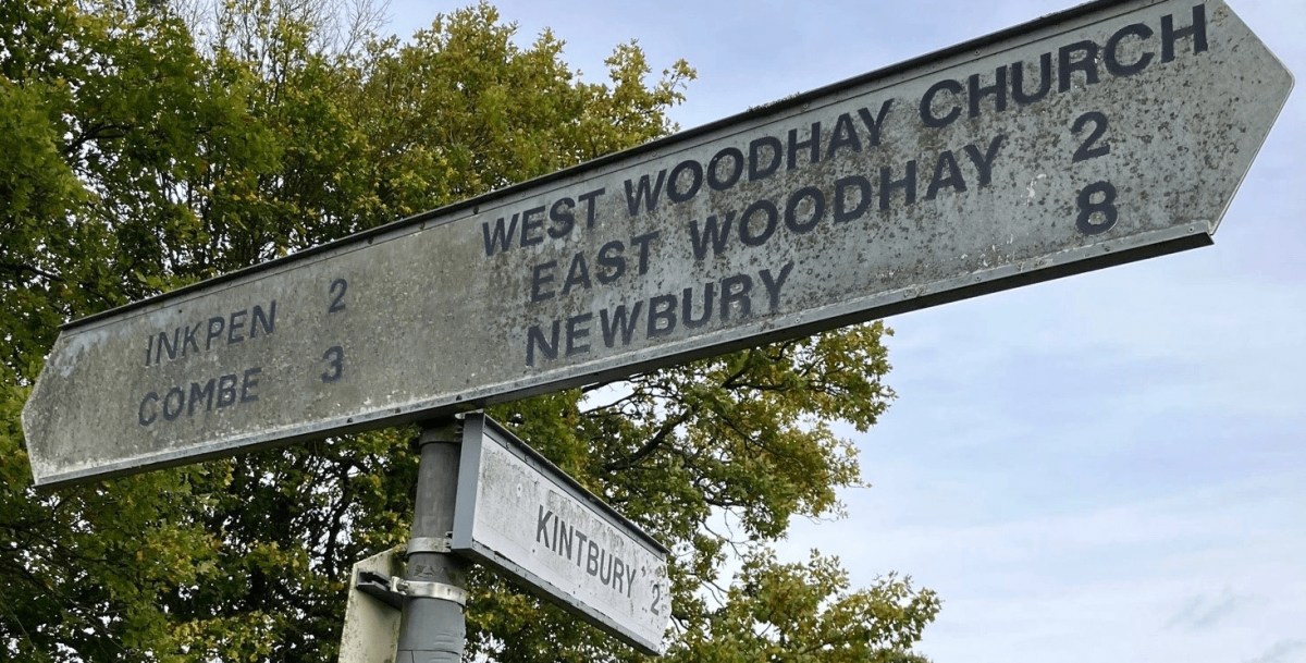
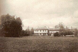
The Inkpen ( or Ham ) white horse was constructed on land owned as part of the Ham Spray estate, just to the east of the small village of Ham in Wiltshire and to the west of Inkpen, Berkshire. In 1869 it was bought by the then thirty year old Charles Wright. In the 1871 census, Wright is described as a farmer of 370 acres employing 8 men and 4 boys, so is clearly quite successful.

Wright had been born in 1839 in the Leicestershire village of Market Bosworth. In 1841 he is living with his grandfather, a clergyman and in 1851 he is a boarder at a grammar school in Derby. By the age of 22 he is living with his father and his older brother Thomas who is in the military.  Charles himself is described as “gent”: a very precise distinction at this socially divided time.

Ten years later, Thomas Wright has a seat of his own: Tidmington House in Worcestershire, where he lives with his wife and eight staff. Younger brother Charles has relocated to the south west.

When Charles Wright bought Ham Spray House, it was a modern building still only around thirty years old. Perhaps Charles wanted to establish his own seat, distinct and away from the family in Leicestershire.

Ham Spray House
Charles Richard Sanders via Creative Commons

Some nineteenth century landowners become high profile figures within their towns or villages and their names feature frequently in the local press. This cannot be said of Charles Wright in the time he lived at Ham Spray House. The only reference I can find to him in local papers, aside from details of the sale of his property, was when he contributed generously, along with other local gentry, to a fund for the sick.

Finding himself in a county famed for its white horses cut into the chalk downland, Wright may have wanted the distinction of adding to that number. Perhaps he wanted to impress his neighbours, or just to add to the view from his house. So, sometime in the early 1870s he had his workers cut the outline of a horse into the downs. The new white horse must have been distinctive enough for the Ordnance Survey surveyors to notice it when working in the area in 1873 and include it on the latest edition of the O.S. map, published four years later..

However, the 1877 O.S. map is the only one to include the new, Inkpen white horse. Sadly, it did not endure partly because it had been constructed by stripping away the turf with out digging and packing out trenches with compacted chalk. Further, subsequent landowners did not bother to clear away the encroaching grass.

Charles Wright died on 12th December 1876 at Ham Spray House. He was only 37.  The estate, his house and all its contents were sold. His time at Ham Spray House, like that of his newly cut white horse on the downs above Inkpen, had been brief.


Ancestry

British newspaper Archive

(C) Theresa A. Lock, 2025

Once a mountain

Walbury Beacon Benefice is named after the point on Walbury Hill where, traditionally, a beacon has been built.

But mind-chains do not clank where one’s next neighbour is the sky.

Thomas Hardy, “On Wessex Heights

Walbury Beacon Benefice is named after the point on Walbury Hill where, traditionally, a beacon has been built. Originally beacons were lit across the south of England as an alert to the danger of invasion. More recently and at least since Victorian times, the chain of beacons has been lit to celebrate royal jubilees. Sometimes known as Inkpen Beacon, at 974 feet above sea level, Walbury Hill is the highest point on chalk in England and the site of Walbury Camp, an Iron Age hill fort, which, I believe, has never been excavated.

A beacon on Walbury Hill/Inkpen Beacon celebrating the Platinum Jubilee in June 2022

It will surprise some people to know that when the Ordnance Survey first surveyed this area, Walbury Hill was measured as being 1,011 feet above sea level, thus making it a mountain! However, a subsequent survey in the late C19th measured Walbury at less than 975 feet and so demoted it to the status of a hill.

Further westward along the ridge is Inkpen Long Barrow, one of only three long barrows in Berkshire but one of a cluster, most of which are located in Wiltshire and Dorset. However, it is not the long barrow that many visitors come to see, but the famous (or perhaps that should be infamous) Combe Gibbet.

Combe gibbet

Many people mistakenly believe that a gibbet was the site of a public execution, but this was not so. The original Combe Gibbet was only used once but it was not for an execution. In 1676, George Broomham and Dorothy Newman were convicted of the murder of George’s wife Martha and son, Robert. They were executed at Winchester but their bodies returned to their home parishes where they were hung on the gibbet – as a deterrent to anyone contemplating committing murder. What contributes to the general confusion between a gibbet and a gallows is the fact that the downland on the north side below the gibbet is marked on OS maps as “Gallows Down” – presumably a misnomer which has stuck!

As many of you will know, the story of Broomham and Newman inspired the then young Oxford graduate John Schlessinger, to make his first feature film, “The Black Legend”. In the late 1940s the Schlessinger family lived at Mount Pleasant, between Inkpen and Kintbury  and so the grisly local landmark would have been a familiar sight to them. With family members and friends from Oxford taking the major roles, John Schlessinger filmed the story of murder during the summer of 1948, using many local people as extras. I doubt any of these villagers had the remotest idea that this young man would one day go on to be one of Britain’s foremost directors winning 7 BAFTAs and an Oscar.

Nearly 20 years later John Schlessinger was to return to Wessex to film his adaptation of Thomas Hardy’s “Far from the Madding Crowd”. Filmed entirely on location in Wiltshire and Dorset, what fascinates me about this later work are the number of scenes which recall moments from Schlessinger’s earlier film. It is as if the inspiration he took from his work around Walbury Hill stayed with him and was used in this, one of the visually most beautiful of British films.

However, it is not only because of the Black Legend that many other people visit Walbury Hill. The Newbury Weekly News archive features various accounts of visits to the area or discussions of its history. Some time in the late C19th, the novelist and poet Thomas Hardy visited Walbury Beacon – though perhaps to confuse us even more, he calls it “Ingpen Beacon” – and referenced it in his poem, Wessex Heights:

There are some heights in Wessex, shaped as if by a kindly hand
For thinking, dreaming, dying on, and at crises when I stand,
Say, on Ingpen Beacon eastward, or on Wylls-Neck westwardly,
I seem where I was before my birth, and after death may be.

Walbury Hill might not be a mountain but it remains a much loved landmark.

Theresa Lock

Thomas Hardy and North Wessex

Think of the author, Thomas Hardy (1840 -1928), and your first thoughts are probably of Dorset, the county most associated with his life and where most of his novels and poems are set.

So, what did this author, most associated with the countryside around Dorchester, have to do with Berkshire?

Think of the author, Thomas Hardy (1840 -1928), and your first thoughts are probably of Dorset, the county most associated with his life and where most of his novels and poems are set.

Fans of Hardy will know that in his novels he identified his semi-fictional Dorset as South Wessex, Wiltshire as Mid Wessex, Hampshire as Upper Wessex and so on, adapting the name of the early medieval kingdom. If you look carefully at the map of Hardy’s Wessex inside most editions of the novels, you will see that North Wessex corresponds to pre 1974 Berkshire with “Christminster” or Oxford, just to the north.

So, what did this author, most associated with the countryside around Dorchester, have to do with Berkshire? Well, Hardy’s paternal grandmother, Mary Head, was actually born in Reading and brought up in Fawley, a village on the downs south of Wantage. In his novel, Jude the Obscure, Hardy gave Jude the surname, Fawley, but chose to identify the village as Marygreen, after his grandmother. Similarly, Wantage becomes Alfredstone after the King Alfred who was born there, and Newbury, Kennetbridge, after its river. Along with Aldbrickham for Reading, all these places feature in Jude the Obscure, Hardy’s novel of 1895.

Another Hardy link with Old Berkshire, this time in reality rather than fiction, is with Denchworth, a village in the Vale of White Horse north of Wantage. Hardy’s sister Mary had trained as a teacher in Salisbury and accepted her first teaching post at Denchworth village school. Quite why she took a post so far north of either her home or the town in which she trained, I cannot find out. I do not believe that teaching posts were so difficult to come by in those days but I might be wrong. Perhaps she had connections with the Wantage area or had been recommended by someone. It would be interesting to find out. Mary was, apparently, very lonely in this isolated spot so her mother allowed her much younger sister Kate to live with her there. Whether Hardy ever visited his sisters in Denchworth we do not know, although it has to be a possibility.

As a successful author, Hardy and his first wife Emma lived for a time in London where they befriended some of the society figures living in the capital at the time. These included Sir Frances & Lady Jeune who, in the later years of the nineteenth century, also owned Arlington Manor, north of Newbury on Snellsmore Common. Hardy came to stay with the Jeunes in their Berkshire home in 1893 when he also visited Shaw House, Newbury at that time the property of the Eyre family.

In October of the same year, Hardy paid a visit to his grandmother’s childhood home up on the downs at Fawley. Sadly he does not seemed to have enjoyed the North Wessex downland, or at least that around Fawley, as he wrote, “Entered a ploughed vale which might be called the Valley of Brown Melancholy”.

I hope that the surrounding downland untouched by the plough was more to Hardy’s liking!

However, we do know that there was somewhere in Berkshire that was very much to Hardy’s liking. Although we do not know for sure when or how he got there, Hardy visited our own Walbury Beacon. We know this because he refers to it – as “Ingpen Beacon”- in his poem of 1896, “On Wessex Heights”.

Perhaps Hardy visited whilst he was staying with the Jeunes the previous year. Maybe they had a very early model of motor car, although it is difficult imagining one negotiating the incline to reach the top. Perhaps Hardy, and whoever was accompanying him, travelled to Kintbury station and made the rest of the journey in a horse drawn vehicle. We shall never know. However, I am sure he would have been fascinated to see the gibbet (in its late 19th century manifestation ) silhouetted against the skyline – I do so hope someone made him aware of the story of George Broomham & Dorothy Newman as I think he would have enjoyed it.

The gibbet as seen today

But it was the hill we know as Walbury Beacon which Hardy particularly enjoyed visiting and compared favourably with other hills across Wessex, inspiring the following:

Wessex Heights

There are some heights in Wessex, shaped as if by a kindly hand

 For thinking, dreaming, dying on, and at crises when I stand,

Say, on Ingpen Beacon eastward, or on Wylls-Neck westwardly,

 I seem where I was before my birth, and after death may be.

In the lowlands I have no comrade, not even the lone man’s friend –

Her who suffereth long and is kind; accepts what he is too weak to mend:

 Down there they are dubious and askance; there nobody thinks as I,

 But mind-chains do not clank where one’s next neighbour is the sky.

Thomas Hardy, December 1896

Theresa Lock

This article was first published in The Beacon in September 2022.

Where in the world is Combe?

Close scrutiny of the 1901 census shows something rather odd about the inhabitants of Combe.  On first sight it would seem that many of the 90 or so inhabitants identified as having been born in Hampshire but were now living in Berkshire – a sort of mass migration across the border to the north. Had they left behind them a deserted village somewhere like Imber on Salisbury Plain or Tyneham in Dorset? If not, what had happened sometime in the previous ten years?

Close scrutiny of the 1901 census shows something rather odd about the inhabitants of Combe.  On first sight it would seem that many of the 90 or so inhabitants identified as having been born in Hampshire but were now living in Berkshire – a sort of mass migration across the border to the north. Had they left behind them a deserted village somewhere like Imber on Salisbury Plain or Tyneham in Dorset? If not, what had happened sometime in the previous ten years?

What had actually occurred happened a long way from Combe; in the hallowed debating chambers and offices of Westminster the late Victorian governments had been bringing in laws to change how the country was being governed at a local level. Late nineteenth century policy changes are totally mind boggling unless you are one of those people for whom study of such minutiae brings you deep joy. However, put simply the 1894 Local Government Act enabled elections to take place for district and parish councillors. In doing so it brought a level of democracy much nearer for many people. This was mostly men, although the 1894 Act enabled women who owned property to vote in local elections.

Before district and parish councillors could be elected, it was necessary to determine where district and more importantly parish borders actually were. A glance at early nineteenth century county maps will show that back then not all county boundaries were where they are now. One such example is Combe which was originally in Hampshire although for the purposes of the Poor Law it was part of the Hungerford Union. This meant that anyone in Combe unlucky enough to fall upon hard times such that they could not look after themselves might find themselves in the workhouse in Hungerford.

In July 1894 a Joint Enquiry was held by representatives of the County Councils of Wiltshire, Berkshire and Hampshire to define more conveniently the county boundaries between those three administrative areas. At that time, the boundary between Berkshire and Hampshire passed right through the middle of Walbury camp and just to the north of the gibbet, as you can see on old OS maps.

Representing Combe, the vicar – and also Poor Law Guardian – Rev George Pearson expressed the view that his parishioners would rather their village to be in Berkshire. It was easier to get to Hungerford than either Kingsclere or Andover for what the Newbury Weekly News reported as “magisterial” purposes and for paying the rates into the Hungerford Bank. Questioned as to where the nearest Union (or workhouse ) was in Hampshire, the Rev Pearson explained that the one in Kingsclere was 10 or 11 miles away across difficult roads. Other members of the Enquiry concurred with this.

Absent from the meeting was Mr A.C. Coles, Combe’s representative of the landed gentry and, presumably, the most significant person in the community. However, his representative, a Mr Browning, informed the enquiry that Mr Coles was anxious that the parish should be transferred to Berkshire as it would be more convenient for highway purposes and that there were only one or two paupers in the parish, anyway.

I have to say the precise significance of this remark is lost on me, although  I would hazard a guess that the implication is that the poor of Combe are not going to be a drain on the rates of those in the Hungerford Union area.

And so, in this rather prosaic way, Combe – despite being on the other side of the one-time mountain and highest point on chalk in England – came in to Berkshire and turned its back on Hampshire. Its ninety-something inhabitants, from the Coles in the manor house to the two paupers in their cottages, moved without going anywhere because the roads into Hungerford were better and more convenient despite the climb up and over Walbury Beacon. The boundary was redrawn so that Berkshire included Combe Wood and Eastwick and there it has stayed ever since.

St Swithun’s church stayed in the diocese of Winchester, at least for the time being. In the years that followed it was transferred to the diocese of Salisbury and then back again, moving eventually to the diocese of Oxford in the early 1960s.

I have heard of other reasons being given for why the county boundary across our benefice was moved. However, I can find no other reasons other than those given above – essentially the convenience of road communications between Combe and Hungerford in implementing the 1894 Act.

I would love to hear from anyone else who might know or have evidence otherwise!

Tessa Lock

This article was first published in “The Beacon” in 2022